Liquid Traces—The Left-to-die Boat Case
This image is drawn from an installation and video work offering a synthesis of the “Left-to-die boat” case. In March 2011 (during NATO’s military intervention in Libya), seventy-two passengers left the Libyan coast heading in the direction of Italy on board a small rubber boat. Despite several distress signals relaying their location, as well as repeated interactions with at least one military helicopter and a military ship, they were left to drift for fourteen days. As a result of the inaction of all state actors involved, only nine of the passengers survived.
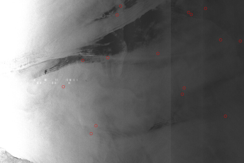
The image, based on satellite imagery from the European Space Agency, explicitly reveals the presence of several large ships located in the vicinity of the migrants’ boat after it had run out of fuel. The bright pixels circled in red each represent vessels informed of the distress of the passengers but who chose not to intervene. While revealing the scale of state abandonment and neglect, the satellite images at once operate at too low a resolution to detect small migrant boats, and therefore cannot illustrate what the regime of border management wishes to reveal: patterns of illegalized migration. By deploying the very technologies of surveillance often used against migrants, these images refocus viewers’ attention on the cruelty of border enforcement. By combining their testimonies with wind and sea-current data as well as satellite imagery, Forensic Oceanography reconstructed the liquid traces of this event, producing a report that served as the basis of several legal challenges.
Full video available at forensic-architecture.org/investigation/the-left-to-die-boat.
The Blackwood
University of Toronto Mississauga
3359 Mississauga Road
Mississauga, ON L5L 1C6
[email protected]
(905) 828-3789
The galleries are currently closed.
Facebook | Twitter | Instagram
Sign up to receive our newsletter.
The Blackwood is situated on the Territory of the Mississaugas of the Credit, Seneca, and Huron-Wendat.